Snow alert: Exact date significant weather event could strike UK as forecasters warn 'snowiest period in 12 YEARS' IS inbound and will last WEEKS

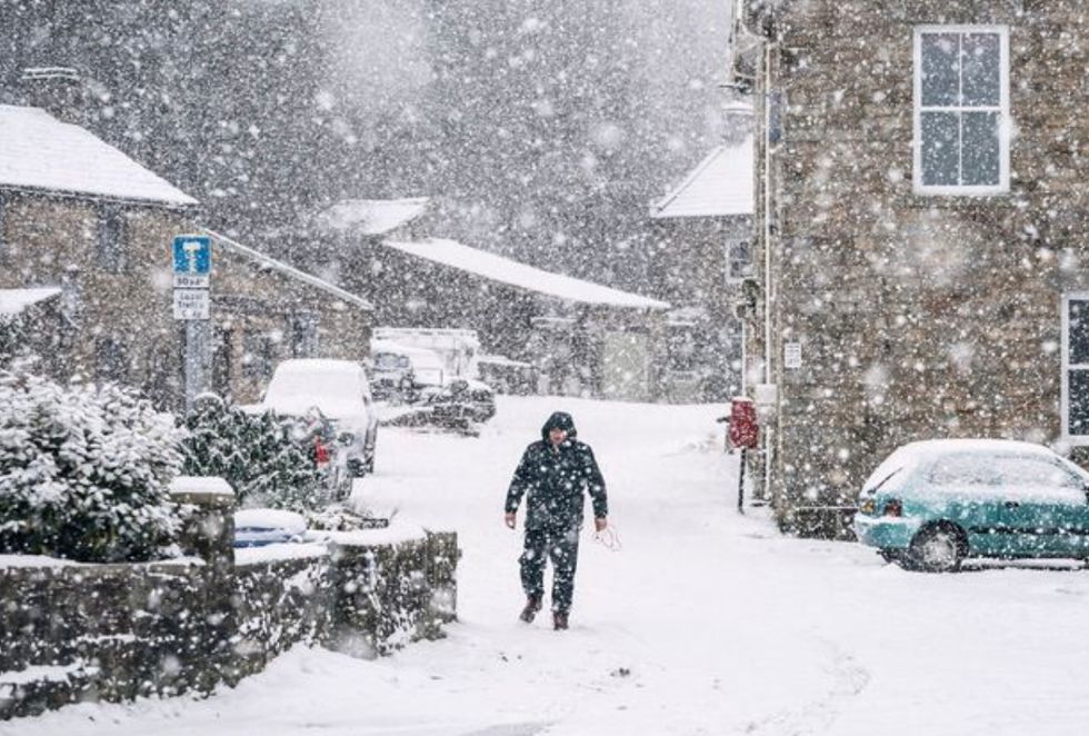
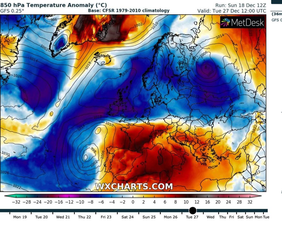
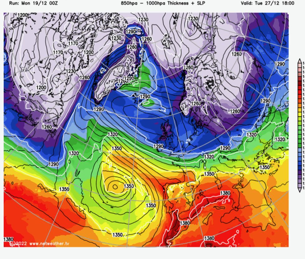
UK snow: Weather forecasters are warning of a significant snowfall event across Britain
PA
Richard Jeffries

By Richard Jeffries


Published: 21/12/2022

- 17:55

Weather warning: Beast from the East set to return bringing heavy snow across UK

BRITAIN is on fresh alert for the most savage Arctic assault in more than a decade to unleash a month of sub-zero temperatures and snow.

Freakishly mild temperatures are about to give way to a Polar blitz which could keep the UK on ice until mid-January.


Britons are facing Christmas in the freezer as a ‘major’ winter blast flings open the gates to -11C gusts, wintry downpours and sheet ice.

Long-range forecasters blame complex meteorological events on the other side of the world unfolding in a similar pattern to the drivers behind the brutal 2018 Beast from the East.

James Madden, forecaster for Exacta Weather, said: “Temperatures will drop in the run up to Christmas and this could bring the risk of snow to parts of the country, some of which may fall to lower levels.

“The rest of December and January are showing signs of frequent spells of cold wintry weather with below-average temperatures and numerous wintry blasts.

“We could now be looking at a lengthy cold period setting in for a number of weeks and the potential for some of the coldest and snowiest weather since December 2010.”

Britain’s weather remains at the mercy of global meteorological patterns which may increase the chances of prolonged cold conditions through winter.

UK weather snow alert: A freezing air mass will sweep across the UK from next week
WX Charts

A La Nina cooling of the eastern Pacific, now in its third year, is already blamed for bizarre weather events across the globe­, including a monster freeze gripping the United States.

Weakening Atlantic pressure patterns between Iceland and the tropical Azores – a so-called negative North Atlantic Oscillation (NAO) – could help drive the UK’s next cold spell.

A Sudden Stratospheric Warming (SSW) causing air high above the North Pole to collapse and push Arctic air into Northern Europe, the driver for the 2018 Beast from the East, may add a third chilly ingredient to the shivering mix.

Mr Madden said the third weekend in January - Saturday 14th and Sunday 15th - could see the peak of the wintry blast.

He added: "The North Atlantic Oscillation (NAO) is changing to a negative phase, and this could boost the drivers of sustained cold weather.

“In addition, we could also see a quite major cold spell from a sudden stratospheric warming (SSW) event developing around mid-January.

“This much colder weather may also be influenced by La Nina which could affect atmospheric circulation and blocking patterns, pressure systems, and most importantly, the run of the jet-stream from early December and January.”

The dire warnings come as Britons bask in an unusual mild spell arriving just days after a minus 12C freeze left swathes of the country under inches of snow.

UK Christmas weather forecast: Britain will be in the freezer again after this weekend
WX Charts

Tropical winds sweeping in from the Canary Islands have rocketed temperatures by around 20C in parts, surging from minus 10C to around 14C.

The mild weather is forecast to hold out through the next couple of days before the UK once more falls prey to the fury of the Arctic.

Jim Dale, meteorologist for British Weather Services, said: “It will stay mild, particularly in the south, before another front moves through from the north bringing colder air into Britain.

“The timing of this is still uncertain and depends on the development of low pressure to the west and high pressure to the east of the country.

“However, it will turn colder from the north through the Christmas period as Polar air moves across the country.”

Mr Dale, author of ‘Weather Or Not?’ was more reserved on the longer-term prospect of a lengthy cold spell.

He said: “There will always be a chance of snow events through this period, particularly in the north.

“Although it could be that we see something more stormy than wintry if our weather ends up being manufactured in the Atlantic.

“In terms of a big freeze holding out until January, the jury is still out on that one, but if it does happen, it is most likely to be in the north.”

Snow is possible into mid-January, according to the Met Office, which also warned of frequent cold spells through the coming weeks.

A spokesman said: “Confidence is relatively low during early and mid-January.

“Temperatures are most likely to be around average, though there is a greater likelihood of cold spells compared to normal.

“Snow remains possible at times, most likely over hills in the north but could fall to lower levels at times.”

In the shorter term, Government forecasters have urged Britons to make the most of the mild weather before the cold bites back.

Weather charts: A polar front can clearly be seen moving across the UK next week
Netweather

Met Office meteorologist Alex Deakin said: “We are likely to see temperatures dropping off after the mild spell, and it is likely to turn colder, but probably not as cold as it has been.

“We are most likely to see north or north-westerly winds, and they will bring some wet weather from the Atlantic and depending on how cold it gets that does bring the potential for some snow.

“We are more likely to see snow compared to the easterly and northerly winds we have seen of late which don’t hold a lot of moisture, so we are potentially going to see a bit more snow in places.”

The last major snow event struck in February 2018 when a Sudden Stratospheric Warming event swept in winds from the east and buried swathes of the nation under inches of snow.

The last widespread White Christmas was in 2010 when a bitter blast ground airports and transport networks to a halt.

Mr Dale, an independent adjudicator for several bookmakers, said: “It is now likely that we see a White Christmas confined to Scotland and northern regions.”

You may like