


BRITAIN is on alert for a Polar blast to unleash a crippling snow deluge next week with up to eight inches forecast as virtually the whole nation is hit by blizzards.
Mild weather will suddenly give way to a bitter three-day Arctic freeze early next week putting swathes of the country at risk of heavy snow.
The UK faces a repeat of the pre-Christmas whiteout which reached as far south as London, although it is likely to be shorter-lived.
The festive freeze was dubbed the 'Troll from Trondheim' due to snow-laden winds ploughing into Britain from the Norwegian Trondheim Fjords.
UK snow forecast: The Met Office says it will turn colder this weekend
PA
Jim Dale, meteorologist for British Weather Services, said: “It will start to get colder at the end of the week and into the weekend as cold air comes down from the northwest, and later the northeast, and there will be a risk of snow.
“We are likely to see another Troll from Trondheim event, although it will be much shorter than the freeze that hit before Christmas, and the worst of the weather will hit the north.
“It is a mini-troll, but something we will probably be talking about this time next week.”
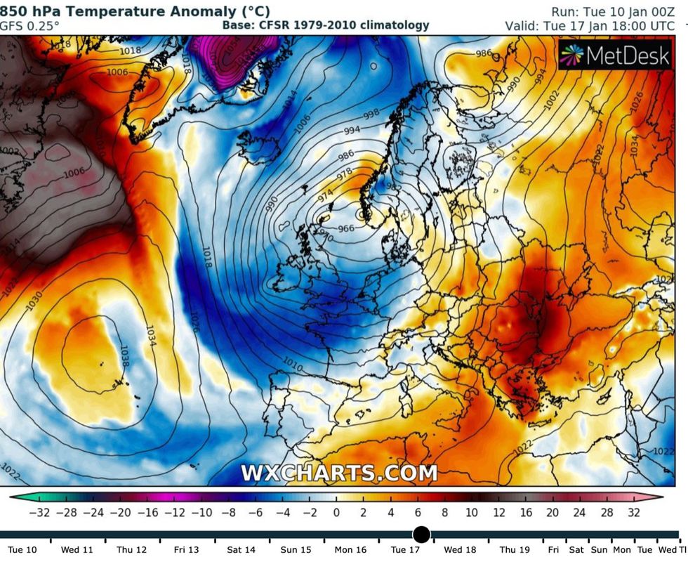
The freak weather U-turn will be driven by a cyclonic low-pressure systems which have powered the recent wind and rain changing direction and veering north.
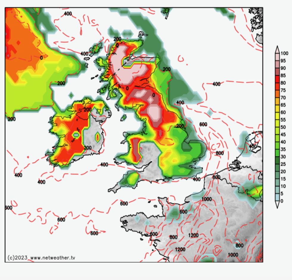
Weather forecasters say there is a risk of near-nationwide snow by Tuesday
Netweather
They will drag a freezing Polar blast across Britain later this week pushing double-digit temperatures back below freezing. Up to eight inches could fall across parts of Scotland with three to four inches more widely, including much further south. Only west Wales and parts of the south west of England are expected to escape the widespread snowfall.
Cold weather will hold out through the weekend before the first signs of heavy snow emerge during the start of next week, with the risk of blizzards peaking on Tuesday (January 17th) .
Mr Dale, author of ‘Weather Or Not?’, said: “Snow is most likely around Tuesday or Wednesday, and this will last for about two to three days, so we are talking about a transient event and not something we expect to last for more than a week like we saw before Christmas.
“This is the effect of low-pressure systems veering northwards and driving a bit of a Polar push.
“The weather will then most likely turn settled, although it will be colder and there will still be the risk of ice and frosty mornings.
“But everybody is going to feel the bite of this cold snap.”
While Scotland and northern Britain are most at risk of snow, some forecasters warn flurries could reach southern regions.
James Madden, forecaster for Exacta Weather, said: “There is the potential for what could be a widespread snow event across large parts of the country, and this is expected around the start of next week.
“The snow is likely to hit northern regions first, but we now expect southern areas to see some snow within this period.
“This could be heavy in parts, and lead to accumulation, and this is likely to cause disruption on the roads and travel networks.”
Powerful winds will drive a crippling whiteout in parts of the country where blizzards threaten disruption on the roads and travel networks, he warned.
Snow alert: A freezing blast will sweep down from the Arctic this weekend
WX Charts
He said: “Northern England could see rain turning to snow in places from as early as this weekend and into Monday of next week.
“People should prepare for disruption, especially on travel networks, as consistent and heavy snow showers and blizzards hit.”
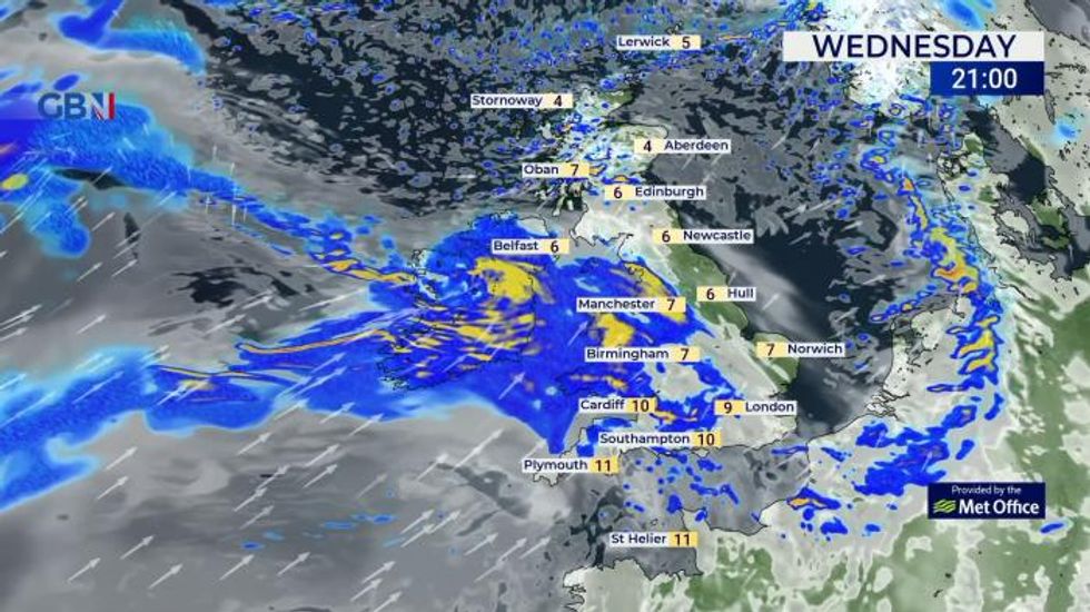
The alert comes as Britain is drenched by a week-long storm deluge which has left swathes of the country flooded or at risk of flooding.
The Met Office has further warnings for heavy rain in force until mid-week across northern Scotland and the West Country.
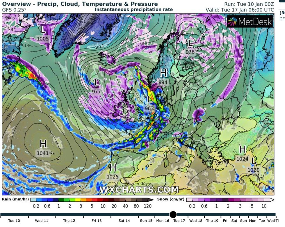
Heavy snow bands will sweep in as a low pressure front passes across the UK next Tuesday
WX Charts
However, government forecasters warn wet weather will give way to a bitter cold blast ahead of the weekend.
Met Office meteorologist Alex Deakin said: “There is lots going on with further wet and windy conditions for most of us over the next few days.
“We will see some snow mixed in with the showers over the Scottish mountains, and the showers will be moving pretty rapidly because of the strength of the winds.
“It may start to turn colder into the weekend.”
Weathertrending’s John Hammond added: “By the end of the week we could see some colder air filter down from the northwest, but by the weekend we could see things turn more wintry more widely.”